Contact:
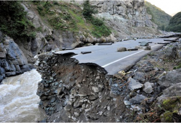
Flash floods are among the world’s deadliest natural disasters with more than 5 000 lives lost annually. Their social, economic and environmental impacts are significant. Accounting for approximately 85% of flooding cases, flash floods also have the highest mortality rate among different classes of flooding, including riverine and coastal. Flash floods differ from river floods in their short time scales and occurrence on small spatial scales, which makes flash flood forecasting a different challenge from large-river flood forecasting. In flash floods forecasting, we are concerned foremost with the forecast of occurrence, and herein focus on two causative events: 1) intense rainfall; and 2) rainfall on saturated soils. Flash floods occur throughout the world, and the development times vary across regions from minutes to several hours depending on the land surface, geomorphological and hydrometeorological characteristics of the region. However, for the majority of these areas, there exists no formal process or capacity for developing flash flood warnings.
To address the issues associated with flash floods, especially the lack of capacity to develop effective flash flood warnings, the Flash Flood Guidance System (FFGS) was designed and developed for interactive use by meteorological and hydrological forecasters throughout the world. In support of the FFGS programme, a Memorandum of Understanding was signed by the WMO, the U.S. Agency for International Development/Office of U.S. Foreign Disaster Assistance (USAID), the U.S. National Oceanic and Atmospheric Administration/National Weather Service (NOAA) and the Hydrologic Research Center (HRC) to work together under a cooperative initiative to implement the FFGS worldwide. The FFGS programme is a public benefit effort on behalf of the partners.
FFGS is necessary to provide operational forecasters and disaster management agencies with real-time informational guidance products pertaining to the threat of small-scale flash flooding. FFGS is a robust system designed to provide the products needed to support the development of flash flood warnings from rainfall events using remote-sensed precipitation (that is, radar and satellite-based rainfall estimates) and hydrological models. To assess the threat of a local flash flood, FFGS allows product adjustments based on the forecaster’s experience with local conditions; incorporation of information, such as Numerical Weather Prediction outputs; and any last minute local observations, including non-traditional rain gauge data or local observer reports.